At NC4 Vertical, we split our Orthographic products into two distinct categories. 'Orthographic' and '"True"Orthographic':

Orthographic Imagery
An orthographic image provides a corrected, top-down view of your site, reducing the perspective distortion found in conventional aerial photographs.
It provides a clear, high-resolution visual reference suitable for planning, documentation, asset identification and presentation.
Where precise positioning or measurement is not required, it provides the benefits of an orthographic view without the additional ground-control workflow required for higher-accuracy georeferenced outputs.
Georeferenced Orthographic Imagery
Our georeferenced orthographic outputs combine corrected aerial imagery with measured ground control and/or RTK positioning to align the imagery to a defined coordinate reference system.
This enables spatially referenced outputs suitable for measurement, comparison, GIS workflows and repeat monitoring. Where project requirements demand it, ground control points and check points can be used to verify positional accuracy.
Outputs can be supplied in formats suitable for GIS, CAD and other spatial-data workflows.
Our Orthographic services include:

2D Orthomosaics
Our 2D orthomosaics give you a complete, top-down view of your entire site—accurate, detailed, and ready to measure.
- One Image, Total Clarity - No more scrolling through dozens of photos. See every ridge, seam, tile, and fault in a single, high-resolution map you can zoom, annotate, and share.
- Measure with Confidence - Take precise, real-world measurements—perfect for quoting repairs, planning installations, or managing contractors.
- Professional Reporting - Whether it’s for insurance, compliance, contractor negotiations or a client - a clean, accurate orthomosaic adds instant transparency to your inspection needs.
- Efficient - No need for repeat visits or site access—just share the image and collaborate from anywhere with your team.
Dense Point Clouds
Dense point clouds turn site imagery into millions of precise 3D points, building an ultra-detailed digital model of your project.
- Detailed Spatial Data – Dense point clouds contain millions of reconstructed 3D points, allowing dimensions, clearances and spatial relationships to be interrogated digitally.
- Flexibility – Point clouds can be imported into CAD and BIM software, forming the foundation for accurate design, retrofits, or extensions.
- Problem Detection – Unlike a standard 3D model, a point cloud reveals imperfections, deviations, or hidden clashes early, before they become expensive design issues.
- Documentation – They provide a defensible, timestamped digital record of a building or site — invaluable for heritage projects, refurbishments, or disputes.
3D Modelling
3D models and digital twins give you a powerful, interactive view of your area of interest—far beyond what photos alone can show.
- Spot Issues Instantly - Zoom, rotate, and inspect every detail from any angle—without stepping foot on a ladder, or MEWP. Ideal for identifying damage, wear, or potential leaks on your site.
- Measure Without Climbing – Interrogate dimensions and distances within appropriately controlled models, reducing the need for physical access solely to obtain measurements.
- Document Everything - Create a timestamped, shareable schedule of condition—essential for pre-lease surveys, dilapidations, insurance claims, compliance, or contractor accountability.
- Save Time & Money - No scaffolding. No repeated visits. Share the digital twin with your team, client, contractor or insurer and make decisions faster—with full clarity.
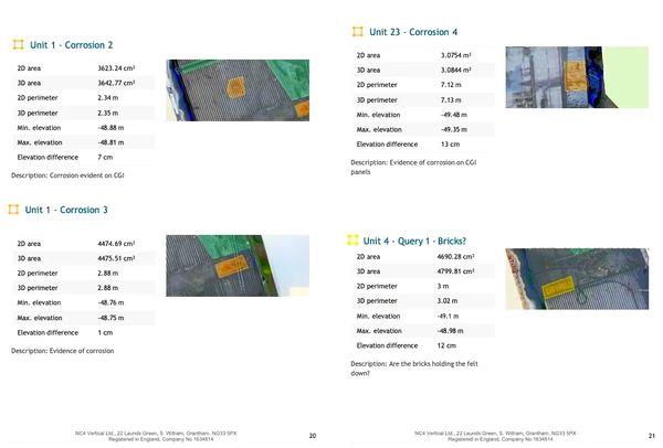
Annotated Site Reports
Our annotated inspection reports combine crystal-clear aerial imagery with notes, so you know exactly what’s happening and are empowered to make informed decisions.
- See It. Understand It. Act on It - We pinpoint defects, damage, and areas of concern, directly on the image, with clear, jargon-free notes.
- Shareable and Professional - Send the report to your contractor, insurer, or client. Everyone sees the same data, clearly explained.
- Document - Need evidence for insurance, compliance, or warranties? Our timestamped, annotated reports give you clear documentation to facilitate your needs.
Applications
Our orthographic data products support a range of applications, including:
- Scheduled reports
- Planned maintenance reports
- Pre-lease inspections & Dilapidations – Enable visual monitoring of progressive degradation
- Schedule of conditions of any elevation
- On site stockpile volume measurement
- Development monitoring - Progressive site monitoring
- Facade inspections
- Site measurement and spatial data capture